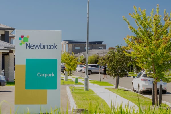
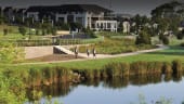
Available homes
Discover the homes currently available across Landcom communities and find the right opportunity to buy with Landcom.
Discover the homes currently available across Landcom communities and find the right opportunity to buy with Landcom.


Discover how Landcom engages with residents, councils and stakeholders to create affordable, sustainable and inclusive communities.
Find out more
Stay up to date with Landcom’s latest industry opportunities, including current tenders, upcoming projects, and ways to work with us.
Find out more Bardia Barracks to support NSW veteran community
 Making new infrastructure happen for North Wilton
 Lismore build to rent homes take shape
 Growing food and density together
 Creating a Spark: Energy Sharing Communities
 Valuing Creative Placemaking Toolkit
'In the Making' will showcase the projects, places and positive impacts we’re delivering across NSW. Explore the first quarterly edition and stay connected as this work evolves.

Explore Landcom’s teams and discover the diverse careers we offer. See how our people work together to create sustainable, inclusive communities.

Discover Landcom’s culture, values and behaviours, and see what makes our workplace inclusive, collaborative and focused on creating real impact.

Landcom is the NSW Government’s land and property developer. We work with government to unlock land...

Bardia Barracks to support NSW veteran community
Making new infrastructure happen for North Wilton
Lismore build to rent homes take shape

Newcastle
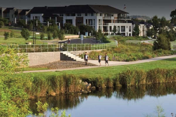
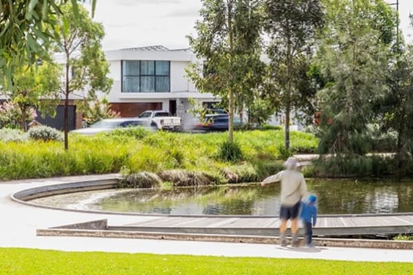
Set around the natural bushland that makes the Lake Macquarie area such a great place to live, Landcom is set to bring more homes to the Garden Suburb community. As a sustainably-designed, all electric neighbourhood, the new precinct will preserve around 28 ha of the site’s bushland - not just for the short-term - but safeguarding it permanently for generations to come. We’ll also deliver at least 30% affordable rental housing*, helping more local people find a secure place to call home in a high-demand area. Delivery of Affordable Housing is subject to funding/subsidies and partnership with a Community Housing Provider.
More homes are on the horizon for Garden Suburb, with a diverse mix of housing types designed to sit alongside existing bushland.
By carefully preserving and regenerating existing bushland, the project supports homes for people and habitat for wildlife, with long-term environmental care built in from the start. It’s a practical, results-driven approach to growth, delivering new homes where they’re needed most, while safeguarding the natural landscape for generations to come.
The project includes:
We’re pleased to announce that the first land release at Sugarwood will take place on the weekend of Saturday 2 May and Sunday 3rd May 2026.
The lots will be offered for sale via an online ballot, that will open at 3pm Tuesday 28 April.
You’ll have 24 hours to register, and all eligible entries during this period will have an equal chance of securing an appointment, so there’s no need to rush. Everyone on our database will get a reminder email on the morning of the ballot open day.
Release 1 at Sugarwood presents a limited opportunity to secure a generous land lots in a thoughtfully planned neighbourhood, with lots ranging from approximately 474m² to 729m² and pricing from $550,000 to $710,000.
• Lot sizes: 474.3m² to 792m²
• Prices start from: $550,000*
• Land registration: expected June 2027**
• Settlement: Within 30 days of registration
• Contract exchange: 5% deposit due within 30 days of contract issue.
TC’s that refer to the above
*Prices are correct as at the time of publication and are subject to change without notice. The starting price is limited to certain lots only. Lot availability is limited and subject to final approval and contract. All images, descriptions, and statements are indicative only and may not reflect the final product. This is not a contract or offer for sale. The advertised price is inclusive of GST. Stamp duty (transfer duty) is payable by the purchaser and is not included in the advertised price. Interested parties should rely on their own enquiries and obtain independent legal and financial advice.
**The dates above are a forecast only which Landcom reasonably believes is correct at the date of publication. As these dates can be subject to change, Landcom gives no warranty or representation as to their accuracy or completeness. To the extent permitted by law, Landcom (including its agents and employees) disclaims any liability whatsoever in connection with, reliance upon, or use of this document by any person. For further information contact the Sales Representative.
Sugarwood sits in Newcastle’s inner-west “sweet spot” – just 20 minutes from the CBD and 15 from the coast.
Commuters benefit from quick access to the M1 and Hunter Expressway. Frequent rail links via nearby Cardiff and Kotara stations and a robust local bus network ensures total connectivity.
Sugarwood’s central location puts everything within easy reach, ensuring you spend less time in transit and more time in the sanctuary you’ve built.

Garden Suburb is ideally placed for work, play, and everything in between.
Families benefit from an established network of local schools, while Newcastle University is just a short commute for students and staff.
For healthcare, the regional John Hunter Hospital is moments away.
Beyond the essentials, soak up the premier retail energy of Charlestown Square and Westfield Kotara, or enjoy lakeside dining at nearby Warners Bay.

Sugarwood’s masterplan honours its elevated topography and native vegetation, creating a sanctuary with stunning bush outlooks. Focused on safety, the estate features shared cycling paths and a new signalised intersection at Myall Road and Gymea Drive.
Staged over four phases, the design prioritises privacy and seamless connection to nearby playing fields. It’s the perfect opportunity for local families to upsize into a modern home in a safe, green suburb.
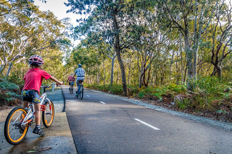
Defined by its landscape, Sugarwood preserves 28 hectares as a permanent sanctuary. This 70% preservation effort safeguards critical habitats for endangered species while providing a natural cooling effect for the whole community. Managed via a formal Biodiversity Stewardship Agreement, our ongoing rehabilitation of native flora creates a thriving green corridor. Here, nature isn't just a backdrop – it’s a protected legacy that will never be built out.

Landcom is creating a resilient, future-proofed community. We are proud to deliver an all-electric, renewables-ready neighbourhood with no reticulated gas. This project leads with heart, dedicating at least 30% to affordable housing to foster a truly inclusive environment. By encouraging solar power, electric vehicles, and low-carbon materials, we are setting a new standard for modern, conscious living in the Hunter.

At Sugarwood, you have the flexibility to bring your own builder or work with our select partner panel to help streamline the process. Our partners offer sustainable, energy-efficient House & Land Packages tailored to the local landscape, providing turnkey solutions that accelerate delivery and simplify decision-making. Whether you choose a custom build or a ready-to-build option, this collaborative approach ensures a faster, more accessible path to your premium, nature-led lifestyle.
Whatever you need, we’re here to help.
gardensuburb@landcom.nsw.gov.au
(02) 9841 8600
If you require the services of an interpreter, please contact the Translating and Interpreting Service on 131 450 and ask them to call Landcom on 02 9841 8600. The interpreter will then assist you with the translation.
What are Landcom’s goals for affordable housing?
For an overview on what Landcom's commitment to delivering affordable housing please visit our affordable housing page.
What does ‘affordable housing’ mean?
Affordable housing is for very low, low and moderate income households where rent or mortgage payments are below 30% of gross household income *. It is priced so that these households are also able to meet other basic living costs such as food, clothing, transport, medical care and education.
* NSW Ministerial Guidelines
Why is affordable housing important?
Affordable housing is an integral part of any community. It plays a pivotal role in enabling social and economic sustainability, to create vibrant and diverse communities.
Without affordable housing, individuals and families may have to sacrifice basic necessities to meet housing costs, potentially leading to displacement that disrupts family and community connection.
This creates a domino effect that impacts local businesses and services: as workers move from an area in search of affordable housing, businesses and essential services find it challenging to attract and retain staff.
Who can live in affordable housing?
Affordable rental housing is for a mix of low or moderate income households. Rent is discounted so that residents are able to meet other basic living costs, such as food, clothing, transport, medical care and education.
Those seeking housing affordability include workers who provide essential services within the community, such as hospitality staff, child-care workers and retail staff.
Is there a need for affordable housing in the area?
The population within the Hunter region is growing, older age groups and smaller households are increasing. At the 2021 Census, low income households were the largest proportion of all households in the Hunter region as a whole and in each Hunter local government area. This suggests demand for affordable housing to rent and purchase by low and moderate income households is strong.
At the same time there has been an increase in the proportion of lower income households in rental stress. At the 2021 Census, in the Hunter, 95% very low income and 74% of low income households were in rental stress, up 2% and 10% respectively from 2016.
The project will provide much needed housing, including affordable rental housing for low income households.
Note : the Hunter region comprises the regional city of Newcastle, plus the local government areas of Cessnock, Dungog, Lake Macquarie, Maitland, Mid Coast, Muswellbrook, Port Stephens, Singleton and Upper Hunter.
*Reference: Homes NSW - Housing Snapshots
How much of affordable housing is part of the project?
As a State-Owned Corporation, Landcom is a commercial business that develops land to achieve both public outcomes and financial benefits for the NSW Government and the people of NSW.
Currently, a minimum of 30% affordable housing is planned for the site. This will provide a positive outcome for the local community and help boost the supply of affordable housing for low and middle income earners.
#Affordable housing is subsidised housing; as such, this project is subject to financing.
Is Landcom making a profit by developing the site?
As a State Owned Corporation Landcom delivers projects to support the NSW Government’s urban agenda. In the midst of the current housing crisis, our role is to deliver more housing supply, diversity and affordability.
80% of Landcom's profit is returned the NSW Government in the form of taxes and dividends. The remaining 20% is retained as the NSW Government’s equity in Landcom to grow the work that we do in the community.
The proposal is for more homes than the previous approval, how has this been able to occur?
Our commitment at Garden Suburb is to provide at least 30% of the total homes delivered on site as affordable rental housing. Within the approved plans we had anticipated 14 affordable homes, but with 42% of local renters in housing stress there is a clear need for more diverse and affordable homes.
Our planning has identified opportunities for more affordable rental housing on the site. We have identified that we could deliver a total of 69 affordable homes with a mix of terrace homes and low rise apartment buildings, subject to securing funding and partnering with a community housing provider to own and manage the homes.
As a government developer, we are required to use available land efficiently to deliver more homes for the community, which is why we are seeking to increase the number of dwellings on a site - helping address the acute housing shortage while still ensuring good design, amenity and respect for the local area.
How was the community consulted on the project?
The project has been in planning for many years and the community has had a number of opportunities to have their say since late 2012.
Prior to lodging the development application with Lake Macquarie Council, Landcom consulted the community in mid-2012 and received feedback from 47 local residents. This feedback was considered and incorporated into the application.
The development application was publicly exhibited in 2013. Further site investigations were undertaken in response to community feedback. The development application was again placed on public exhibition for further consultation in 2018, with an Addendum Biodiversity Assessment Report and additional significance assessments for the threatened species listed within the Environment Protection and Biodiversity Conservation Act (1999) and the Biodiversity Conservation Act (2016).
Through the development assessment process, we undertook further in-depth site studies from 2019-2020. In late 2020, Council issued a notice for interested community members to attend a public meeting to make verbal submissions to the Hunter and Central Coast Joint Regional Planning Panel.
The Regional Planning Panel confirmed that Landcom had adequately addressed issues of community interest and that no new issues had been raised at the public meeting.
The final documents including a document summarising the result of the public exhibition and the Public Submissions Reponses Summary can be found here.
In 2023 the Commonwealth Department of Climate Change, Energy, the Environment and Water publicly exhibited our assessment relating to clearing of an endangered species of native shrub before granting approval.
What auditing and reporting will occur for the project?
An annual compliance report must be prepared and will be published on the project webpage. An independent audit of compliance with the consent conditions must be conducted every three years.
What consultation has Landcom done with the Aboriginal community?
As part of the planning for the site, two Aboriginal Heritage Due Diligence Reports were undertaken. The assessment was required in in accordance with the Due Diligence Code of Practice for the protection of Aboriginal Objects in NSW (2010). The study areas included both the stewardship and development sites, and the report covers an area of 11 hectares.
The investigations identified no items of Aboriginal cultural heritage within the study area. The reports were part of the Development Application which was approved by the Hunter and Central Coast Regional Planning Panel in December 2020, with deferred commencement conditions.
Landcom has been in discussions with the Awabakal Local Aboriginal Land Council regarding the stewardship site and has also notified the Kirinari Hostel, which adjoins the site offering to meet with them should they have any questions regarding the mine subsidence remediation works being undertaken in December 2024 and January 2025.
Why is Landcom impacting high quality bushland to only deliver a small number of homes?
NSW is in the grip of a serious housing crisis and homes need to be delivered to meet community need.
Plans provide for approximately 105 homes to be built, including some affordable housing for lower to moderate income households. Importantly, the majority of the site, approximately 70% (around 28ha of bushland), will be protected and managed as a biodiversity stewardship site in perpetuity.
As such, the project seeks to balance the need to develop land for much needed housing, with regeneration and protection of bushland.
When did construction of the subdivision start?
The subdivision construction started in March 2025. The construction program is around 12 months, and residents are expected to move into their new homes in 2026.
Will fencing be installed around the development site?
During construction, the development area will be fenced to provide for public safety.
A permanent four-metre high fence will be constructed between the development area and the Lance York Oval to help stop balls from the sports fields entering the site.
Does Landcom have to clear all the site?
No.
Approximately 70% of the site, which is around 28ha of the bushland on site is being protected and managed as a biodiversity stewardship site in perpetuity. We also aim to keep a number of mature trees within the development area, including several large, healthy native trees close to Myall Road. Where possible, existing hollow logs will also be reused as 'ground furniture' for animals on the stewardship site.
What are the vegetation disturbance limits and how are they relevant to the project?
Disturbance limits dictate that clearing cannot occur outside of the development area and restrict the clearing of an endangered species of native shrub, Black-eyed Susan (Tetratheca juncea) to within the development footprint.
The limits also state that clearing cannot occur within the biodiversity stewardship site, except for work approved by the Commonwealth Department of Climate Change, Energy, the Environment and Water such as the mine subsidence pothole remediation works.
Once complete will the project cause traffic congestion?
Council has determined that the development will provide good connectivity for vehicles and pedestrians. Traffic studies undertaken by consultants suggest impacts to surrounding streets will be minimal.
The Gillian Crescent extension will provide additional access in case of emergency and/or delays at the main Myall Road intersection.
How will impacts to wildlife be managed during clearing works?
A staged clearing approach will be adopted during construction to give wildlife the chance to relocate. Hollow bearing trees will be felled last. Connectivity will be maintained to the surrounding bushland for as long as possible. Clearing will be supervised by multiple accredited ecologists.
How will Landcom keep the native wildlife safe when clearing the land for the subdivision?
We are working in accordance with a Vegetation Management Plan developed by an ecologist and approved by the Commonwealth Department of Climate Change, Energy, the Environment, and Water.
Are there any road upgrades to support the development?
The intersection upgrade was a condition of the development application and detailed planning is underway. The detailed design for Myall Road works including the upgraded intersection is still being finalised.
The development will include new and upgraded roads and intersection:
What is the status of the road and intersection upgrades?
The Myall Road and Gymea Drive intersection upgrade is a condition of the approved development application. The detailed design for the intersection upgrade is being finalised. However, the signs and pavement marking plans and the traffic signals plan have been approved and are available here.
Once the design work is complete, we will post the detailed designs on our webpage and provide further details to adjoining neighbours and the community.
How will stormwater from the development area be managed so it doesn’t run off into surrounding areas?
Two bioretention basins have been approved as part of the Subdivision Works Certificate to treat stormwater runoff. A new system of gutters and pipes will be installed to channel stormwater runoff away from the development area and prevent flooding.
To manage water run off & soil erosion during construction, some or all of the following control mechanisms may be adopted:
What is the process if unexpected finds such as asbestos are found on site during clearing works?
Any contamination found will be managed in accordance with the approved Remediation Action Plan and the regulatory framework.
How will construction impacts be minimised for neighbours?
Construction impacts will be managed through appropriate mitigation measures. We will notify nearby residents of planned works and provide channels for them to ask questions or make complaints.
Construction is inherently noisy, and construction sites can get dusty. Works will be carried out in accordance with the approved Construction Management Plan to minimise the impacts to the community.
Measures to minimise impacts on the surrounding area will include:
Work hours are: Monday to Friday 7am – 6pm, Saturday 8am – 1pm and no work on Sundays or public holidays
Are any open spaces being delivered?
To maximise the area of conserved land and noting the site’s location close to other open spaces, no new open space will be delivered as part of the project.
Why did the the Nature Markets and Offsets Division approve the biodiversity stewardship site when the Regional Planning Panel advised that the Biodiversity Conservation Trust needed to approve it?
The Biodiversity Conservation Trust and Nature Markets and Offsets Division both operate with the NSW Department of Climate Change, Energy, the Environment and Water. Due to changes within the NSW Department Climate Change, Energy, the Environment and Water, final approval of the biodiversity stewardship site was provided by the Nature Markets and Offsets Division. Ongoing monitoring of compliance is overseen by the Biodiversity Conservation Trust.
Will the access tracks in the biodiversity stewardship site be suitable for people with all abilities?
The tracks will be natural dirt tracks, with some boardwalks over waterways. While paths will be maintained and should be suitable for most ages and fitness levels there are some steeper sections of the site and people with limited mobility may need some assistance.
How will impacts from the new development on wildlife in the biodiversity stewardship site be minimised?
The vegetation management plan outlines a range of measures to minimise impacts on wildlife. For example, traps will be used to keep domestic cats out of the bushland and regular pest species monitoring will occur. Regular monitoring of threatened native fauna will also occur to ensure their numbers remain stable.
To minimise bushfire risk to future properties, will any vegetation in the biodiversity stewardship site be cleared to provide a buffer (asset protection zone) between the bushland and the buildings?
No, vegetation will be cleared in the biodiversity stewardship site to provide asset protection zones. However, there are various asset protection zones located within the development footprint which will protect future properties from bushfire risk.
How will the bushland in the biodiversity stewardship site be protected in perpetuity?
Landcom has paid $2.48 million to the NSW Biodiversity Conservation Trust which will fund the rehabilitation and ongoing maintenance of the bushland in perpetuity.
How will the funds be audited to verify that they are being spent in accordance with requirements?
At the end of every year, a compliance report must be prepared and submitted to the NSW Department of Climate Change, Energy, the Environment and Water to demonstrate we have undertaken the required actions to rehabilitate the site according to the approved management plan.
Who will own and manage the biodiversity stewardship site?
Landcom currently owns the stewardship site and will manage it in the short term. We are working with key stakeholders to explore opportunities to potentially transfer ownership and ongoing management of the site. If ownership of the site is transferred, the new owners will be required to maintain the stewardship in perpetuity according to the current management plan.
Can the community oversee the management of the biodiversity stewardship site?
Yes, there is an important role for the community to advocate for the health of the bushland in the stewardship site. The community can submit a report to the NSW Department of Climate Change, Energy, the Environment and Water if the site is not being respected or managed in accordance with the approved vegetation management plan.
Will the access tracks in the biodiversity stewardship site be suitable for people with all abilities?
The tracks will be natural dirt tracks, with some boardwalks over waterways. While paths will be maintained and should be suitable for most ages and fitness levels there are some steeper sections of the site and people with limited mobility may need some assistance.
Will the health of the bushland in the biodiversity stewardship site be monitored?
Yes, the NSW Department of Climate Change, Energy, the Environment and Water will monitor the health of bushland in the stewardship site and ensure the approved vegetation management plan is being fully implemented.
After 12 months, the vegetation management plan may need to be updated with new strategies in response to changes in the condition of the bushland.
The vegetation management plan will be reviewed and updated every five years to reflect changes in environmental conditions, regulatory requirements and the health of the bushland. Management strategies outlined in the original plan may need to be adjusted to maintain optimal ecological balance and achieve desired outcomes in the stewardship site.
What is the registration number for the biodiversity stewardship site?
The stewardship site was recently registered by the Nature Markets and Offsets Division of the NSW Department of Climate Change, Energy, the Environment and Water. The registration number is - BS0162.
Why was the covenant linked to the development application to protect the bushland removed from the stewardship site?
The Nature Markets and Offsets Division of the NSW Department of Climate Change, Energy, the Environment and Water confirmed the condition for a covenant was redundant and was not required to execute the Biodiversity Stewardship Agreement. Ongoing monitoring to ensure compliance with the Biodiversity Stewardship Agreement is overseen by the Biodiversity Conservation Trust.
What monitoring is in place for the new nest boxes on the stewardship site ?
The nest boxes come in various shapes and sizes to cater for the different species that will use them. For example, owl nestboxes are larger than glider, possum and lorikeet nestboxes. The nestboxes are a mix of salvaged hollows and manufactured boxes. We will record the number of nestboxes removed from the development footprint to ensure an equal number are installed in the stewardship site.
The nest boxes will be monitored to determine evidence of occupation and the condition of artificial hollows. Any nest boxes that are damaged will be replaced.
How will bushland in the biodiversity stewardship site be managed moving forward?
Native vegetation, threatened species, pests and weeds will be managed as part of an approved stewardship site management plan.
The management plan includes actions that must be undertaken to meet the Conditions of Consent, and to ensure the ecological condition of the stewardship site is improved and maintained in perpetuity.
Will access to recreational space and bushwalking trails be restricted when the project commences?
There may be periods where the site is closed or restricted while remediation and construction works are carried out, however the stewardship site will remain publicly accessible in the long term.
The biodiversity stewardship site will keep some walking trails for recreational access. Several smaller trails within the stewardship site will be closed to help the bush regenerate.
How do I register for land sales?
The marketing strategy for land sales is still being finalised. If you are interested in land sales, we encourage you to subscribe to our newsletter to stay up to date on the project.
What cultural investigations have been undertaken on the site?
As part of the planning for the site, two Aboriginal Heritage Due Diligence Reports were undertaken. The assessment was carried out in accordance with the Due Diligence Code of Practice for the protection of Aboriginal Objects in NSW (2010). The study areas included both the stewardship and development sites.
The investigations identified no items of Aboriginal cultural heritage within the study area. The reports were part of the Development Application which was approved by the Hunter and Central Coast Regional Planning Panel in December 2020, with deferred commencement conditions.
When was the project approved?
Following public exhibition of the development application in 2013, and subsequent community feedback, further site investigations were undertaken. The application was publicly exhibited again in 2018, with an Addendum Biodiversity Assessment Report and additional significance assessments for the threatened species listed within the Environment Protection and Biodiversity Conservation Act (1999) and the Biodiversity Conservation Act (2016).
The project received approval from the Hunter and Central Coast Joint Regional Planning Panel in 2020, subject to deferred commencement conditions.
Approval under the Commonwealth Environment Protection and Biodiversity Conservation Act 1999 was received in December 2024.
In late 2024/early 2025, we remediated 12 mine subsidence potholes in the stewardship site. The potholes had to be remediated in accordance with Conditions of Consent and works must comply with a Vegetation Management Plan which was approved by the Commonwealth Department of Climate Change, Energy, the Environment and Water.
Does the project rely on older environmental studies that are inconsistent with current planning requirements? Why was no environmental impact statement completed?
As the proposal was not a State Significant Development Application, an Environmental Impact Statement was not required. Comparable technical studies have been completed including three separate biodiversity assessments and several in-depth site investigations. Studies found there is likely to be no significant impact on vulnerable flora and fauna, like powerful owls and squirrel gliders, with suitable mitigation measures in place. Studies were assessed by Lake Macquarie City Council and referred to relevant State Government agencies for review, following which the Hunter and Central Coast Regional Planning Panel approved the development in late 2020.
The development application was publicly exhibited in 2013 along with associated technical reports. Further site investigations were undertaken in response to community feedback. The development application was again placed on public exhibition for further consultation in 2018, with an Addendum Biodiversity Assessment Report and additional significance assessments for the threatened species listed within the Environment Protection and Biodiversity Conservation Act (1999) and the Biodiversity Conservation Act (2016).
Through the development assessment process, we undertook further in-depth site studies from 2019-2020. In late 2020, Council issued a notice for interested community members to attend a public meeting to make verbal submissions to the Hunter and Central Coast Joint Regional Planning Panel.
The Development Application was approved by the Hunter and Central Coast Regional Planning Panel in December 2020, with deferred commencement conditions. The Regional Planning Panel confirmed that Landcom has adequately addressed issues of community interest and that no new issues had been raised at the public meeting.
The final documents including a document summarising the result of the public exhibition and the Public Submissions Reponses Summary can be found here.
Why can’t Landcom develop elsewhere – there are many other already cleared sites in the area?
We use a range of criteria when evaluating potential development sites. These include location, zoning, availability of services, potential to accommodate affordable housing, heritage and flooding constraints to identify if they are feasible to develop.
The NSW Government is committed to confronting the housing crisis head on, which means ensuring we have more housing supply. The Garden Suburb project provides an opportunity to balance the need to develop land for much needed housing, with the opportunity to improve and protect existing bushland.
What safeguards will be put in place to limit the impacts to bushland?
The required pothole remediation works are being supervised by a qualified ecologist. At the commencement of works, a full team briefing involving civil contractors, geotechnical engineers, ecologists and Landcom representatives was held to run through the required works and all the environmental and safety protocols.
The principal ecologist has directed that vegetation clearing is to be minimised as far as practical, and that the supervising ecologist will work closely with the civil contractors to identify the most suitable access pathways and machinery working areas. In particular, important features to be preferentially avoided included:
If any native animals are found, the ecologist will handle the situation to comply with animal ethics licensing protocols.
Wherever potential safety risks are identified for machinery operation, such as steep slopes, the ecologist and civil contractor will work together to identify alternative pathways that minimise impacts to the environment and protect the machine operators.
How can we contact the Landcom team about the project?
The community can contact the project team when works are occurring (i.e. Monday to Friday, between 7am and 5pm) on T: 1800 714 321or alternatively the Landcom office on 9841 8600 or E: gardensuburb@landcom.nsw.gov.au and find more information online at: www.landcom.com.au/garden-suburb.
Will the bushland be closed to the public during the pothole remediation works?
No. Given the low impact of the pothole works, the public will still be able to access the bushland during the works period.
Signage has been erected to define work areas. This is to ensure that while works are being carried out, the public is safe from moving machinery.
Is there new planting going into the stewardship to support remediating the bushland?
Targeted supplementary native planting will be undertaken once the mine subsidence works are complete and the stewardship site is registered. This will increase native plant species and cover, enhancing the composition and density across the site.
Focus will be on rehabilitating the tracks created by mine subsidence works, which will be temporarily fenced to allow for vegetation to regenerate.
Why did Landcom give a short notice period to the community ahead of pothole remediation works commencing?
NSW is in the grip of a serious housing crisis and homes need to be delivered. The potholes need to be remediated without delay to enable the stewardship site to be registered ahead of site works commencing in early 2025.
The pothole remediation works could only commence once Commonwealth approval under the Environment Protection and Biodiversity Conservation Act was obtained. The timing of the works is necessary to meet future planning and programming requirements.
As the pothole remediation works are determined to be low impact causing minimal damage to the bushland, Landcom did not consider it necessary to provide more notice to the community. The pothole sites will be monitored to enable natural bushland to reestablish. The community will be informed well in advance of main civil works commencing on the development site.
Why was December/January chosen to complete the works?
The works have commenced in December and will continue in January following recent receipt of the Commonwealth approval under the Environment Protection and Biodiversity Conservation Act, which was the last required environmental approval.
This is the most suitable time of year as it falls outside the recorded Powerful Owl nesting period, and hence greatly limits chances of any direct disturbance to nesting activity and young fledgling birds.
What safeguards will be put in place to limit the impact of the pothole remediation works on the threatened Powerful Owl?
As Powerful Owls (Ninox strenua) are listed as a threatened species, works have been carefully planned to minimise the impact on them.
Works are being carried out in December and January as the owls are not nesting at this time, and any fledglings born last season will have left the nest.
Retention of any large hollow bearing trees will ensure that no direct impact to Powerful Owl nest sites will occur, noting that nests are usually active in the period from April to October.
The closest pothole being remediated is around 100m from the nearest nesting tree. As such, fencing is not required. Our ecologist has advised that works are unlikely to have a negative impact on the owls.
How will mine subsidence risks be managed?
The development footprint reflects a range of environmental factors including the impacts of historic mine subsidence that were identified through geotechnical testing. Risk assessments have identified 12 mine subsidence potholes in the north-east and south-east of the stewardship site that need to be remediated before the site can be established.
This will involve backfilling each pothole with fill material to ensure public safety. The remediation of the potholes must be completed before the stewardship site can be registered and to satisfy the Conditions of Consent for the development application issued by the Hunter and Central Coast Regional Planning Panel.
Pothole works were approved by the Federal Department of Climate Change, Energy, the Environment and Water and will be supervised by an ecologist.
Why can't the mine subsidence potholes be left?
We understand that backfilling the potholes will cause some disturbance to bushland. However, given some of the potholes are up to three metres in depth, they present a public safety risk for the community who regularly access the site.
Without remediation, they will continue to deteriorate, ultimately causing further damage to the site. Furthermore, as part of the Conditions of Consent, we must remediate safety risks posed by shafts and potholes associated with mine subsidence before the stewardship site can be registered.
What do the pothole remediation works involve and how will native bushland and animals be protected during the works?
Works were approved by the Commonwealth Department of Climate Change, Energy, the Environment and Water.
All work will be supervised by an ecologist and efforts will be made to utilise existing tracks to access the potholes to minimise vegetation disturbance.
The ecologist will work closely with the team to carefully navigate the site and minimise disturbance to flora and fauna.
For more information, please refer to the community notice for these works.
Why is the site being rezoned?
Rezoning is required to create both the residential and affordable housing lots.
The zoning and land uses that guide what can be built on the site are in the historical Local Environmental Plan dating back to 1984. This is outdated and does not match the current standardised zonings and land uses applied in Local Environmental Plans today.
We are updating the zoning to simply make the existing zoning consistent with current standardised zonings. This is an administrative update. It does not change the existing land uses that guide what can be built on the site and it is not a new development proposal.
What was involved in the rezoning proposal?
Landcom submitted a detailed planning proposal to the Department of Planning, Housing and Infrastructure, who considered the submission before placing it on public exhibition.
The rezoning proposes R2 Low Density for the 66 residential lots on the southern side of Myall Road, R1 General Residential for the two affordable housing lots on the southern side of Myall Road and R1 General Residential for the lot on the northern side of Myall Road.
Once the public exhibition has closed, the Department will consider all submissions before making their determination.
Will the community have their say in the rezoning process?
The planning proposal has been placed on public exhibition by the Department of Planning, Housing and Infrastructure for community feedback until 20 April 2026. To view the planning proposal please visit the NSW Planning Portal.
Why is Landcom allowed to increase the amount of housing on site without proper planning approvals?
Some of our projects follow a self assessment pathway under Division 5.1 of the Environmental Planning and Assessment Act 1979. To determine whether an activity can proceed, we must assess any environmental impacts and comply with strict State planning requirements.
This pathway helps deliver affordable rental housing more efficiently while ensuring councils and communities have opportunities to have their say on proposals.
Why can Landcom determine some development proposals, but others must be referred to another consent authority?
Most of our development proposals are assessed under Part 4 of the Environmental Planning & Assessment Act 1979 with a local council, a planning panel or the Minister for Planning and Public Spaces acting as the ‘Consent Authority’. Through this process, proposals get placed on public exhibition and independently assessed before a decision is made whether they can go ahead.
Sometimes Landcom can determine certain activities without development consent under Division 5.1 of the Environmental Planning & Assessment Act 1979. For these activities, we must assess the environmental impacts and consider whether there are ways to reduce them before deciding whether to proceed.
How long has Landcom been able to self-assess development proposals?
We have been able to self-assess certain minor infrastructure works, such as roads and parks, for many years. Since December 2023, a new self-assessment pathway for 100% affordable housing developments with up to 75 homes is available to Landcom.
This change is part of the NSW Government’s suite of planning reforms to help build more affordable homes faster.
What activities can Landcom self-assess?
The activities Landcom can self-assess are listed in the:
How are environmental impacts assessed through the self-assessment process?
While self-assessment means that a development application does not need to be lodged with an external consent authority, like a local council, we must still thoroughly consider the likely impact of the activity on the environment and document the impacts in a Review of Environmental Factors report.
Where a proposal might significantly impact the environment, we may also be required to carry out specific biodiversity studies or an Environmental Impact Statement and publicly exhibit these documents before we can make a decision on the proposal.
What must be considered through the environmental assessment process?
Clause 171(2) of the Environmental Planning and Assessment Regulations 2021 lists the factors that we must consider through the environmental assessment process.
Who makes the final determination for proposals that Landcom self-assesses?
After reviewing all documentation, Landcom’s CEO can make the final determination on a proposal. The CEO will look at whether the environmental assessments are adequate and the proposed activity can go ahead, or if additional steps may be needed to reduce or minimise environmental impacts before the activity can start.
What assurances are there for the integrity of the environmental assessment process?
As a public authority, we must make sound and defensible decisions about proposed activities that we assess under Division 5.1 of the Environmental Planning & Assessment Act 1979.
The steps and rules for this process are in the Guidelines for Division 5.1 Assessment.
Landcom’ s process includes several measures to ensure compliance with the legal requirements and ensure fairness. For example:
How is the community consulted as part of the self-assessment process?
As a minimum, the law requires us to notify and invite comments from local councils, agencies and immediate neighbours.
For affordable housing proposals or other proposals that may impact or be of interest to the community, we may provide extra notification and opportunities to engage through the environmental assessment processes.
Are documents related to the self-assessment process made public?
For activities over $5 million, we must publish all relevant environmental assessment documents and supporting technical reports on the NSW Planning Portal. This provides transparency and accountability to support robust and defensible decision making for proposals that we determine through self-assessment.
How was the need for the intersection upgraded identified?
The intersection upgrade was identified as part of Council’s Development Contributions Plan for the Glendale Catchment.
The upgrade is a requirement of the conditions of consent for the Garden Suburb subdivision.
Who approved the intersection design?
Transport for NSW approved the design of the traffic control signals for the intersection. The civil design for the intersection is under assessment by Lake Macquarie City Council.
Further information can be found in the Signs and Pavement Marking Plan and the Traffic Control Signals Plan.
How was the Myall Road intersection designed?
Intersection design is guided by state and national standards to maximise safety and operational efficiency, leaving limited scope for the community to influence technical design outcomes.
The design was informed by Transport for NSW and modelling advice from specialist engineers and traffic consultants.
When will the works on the intersection start and how long will it take?
Works are planned to start in mid- 2026, and are expected to take ten months, weather permitting.
What will be the changes at the intersection of Reserved Road and Myall Road ?
Motorists will still be able to turn left in and left out of Reserved Road, however they will no longer be able to turn right in and out of Reserved Road.
Any further design questions should be directed to Council.
Will there be changes to the access to Lance York Oval on Myall Road?
Motorists will still be able to turn left in, turn left out, and turn right to enter the oval; however, they will no longer be able to turn right when exiting the oval. Motorists who need to turn right out of the oval onto Myall Road must turn left and then use the roundabout further west at Newcastle Street.
Any further design questions should be directed to Council.